What is the tallest mountain in Asia? Mount Everest. Ok, let’s try again. What is the tallest non-Himalayan Mountain in Asia? The answer is Mount Kinabalu in Malaysia. It reaches a grand elevation of 4,095m and if one wants to scale it, that’s a two-day 18km hike up and down. This was the main goal for our Singapore/Malaysia trip, to scale this beast of a mountain. To get to our destination after our 2-day stopover at Singapore visit (see my blog on Singapore) we took a short flight from Singapore to Kota Kinabalu International Airport (KKIA). Before I begin describing our adventures in Malaysia, I just want to state at the very beginning that we had prepared for this hike for the past 3 months before actually going on the trip. So, make no mistake this was not going to be a walk in the park but it would be worth it.
We came to Kota Kinabalu two days before the trek started because we wanted to snorkel in the South China sea in the Tunku Abdul Rahman marine park where we stayed at the Hotel Mercure. We were there the days before and one day after the hike and were able to store our luggage with them so that we didn’t have to carry it around with us. It also gave a comfortable place to stay for a day after our hike. After we did our snorkelling (I’ll upload a video on my YouTube channel covering that), we got a cab to Kota Kinabalu National Park.
We were staying at a place called J Residence from where we would be picked up to start the trek the next morning. We chose this place instead of staying inside the park as we didn’t want to stay in a dormitory or pay really expensive rates for an independent room. We were late for dinner and just about managed to get some food from a restaurant that was about to close and ate eggs and rice as our last meal before the big hike.
The next day was our trek day 1. Just to recap, it was going to be a two-day trek where we would have to cover 6 km up the first day and 2.72 km up the second day, we would have to climb to an altitude of 3272.2m above sea level where we would stay the night at the end of day1. The next day we would climb to Low’s Peak, a total hike of 8.72 km from Timpohon Gate (the starting point) at an altitude of 4095.2m above sea-level and then come down all the way on day2.
We woke up early at J Residence and prepped ourselves for the climb. After packing up our bags and changing into our trekking clothes we got into a van which would take us to the Park Entrance. At the entrance we received water pouches, our lunch boxes for later in the day and our permits. Here, we also had to sign some indemnity forms which granted the park “exemption from legal liability for our actions.”
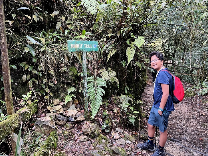
After the forms were collected, we handed over our extra bag to our assigned guide-cum-porter. Some introductions later we learnt his name was Jerro and he would be with us throughout the trek. The park has extensive regulations for guides and hikers(I have included some details and web-links at the end this blog). Then, we loaded back into the car for the last time for 34 hours and were driven to Timpohon Gate where we would be starting the trek. Jerro quickly explained the trek detailing that we would have lunch at the 4-kilometre point (Layang-Layang) then from there to the sixth kilometre, it would be a harder climb. we would spend the night at the 6- kilometre point, then wake really early for the next part.
When we began the first 250 or so metres were downhill giving us an easy start. After that the climb transferred to more steps and slopes which we were easily able to do, thanks to the training we had put in climbing stairs back home in our 46-storey building. We reached the first shelter in about half an hour. These shelters were positioned at points on the trail to provide seating and restrooms. We took advantage of these as we took our breaks to grab a bite and have water. Sitting at the shelters you also got to look around at the vegetation and surrounding scenery.
At the first shelter, we had some water and an energy bar. The second kilometre was harder for us to climb up and we took a lot more time. We took note that we were sweating a lot less than most blogs had suggested. We guessed that this was because of the rain from last night. This rain had sadly not let the previous day’s group go to the summit. We hoped there wouldn’t be an encore as we steadily climbed up to the next shelter.
The second kilometre was a true struggle so I went very slowly. We took a longer break at the 2- Kilometre breakpoint to eat some apples, and with renewed energy returned to the climb. The third kilometre lent us some relief with a less steep and difficult path that we managed to do nice and easy. Around us were big trees and bushes that provided us with shade that helped us climb without the sun in our eyes and stopped us from sweating too much. We took in the sites as we were climbing up towards the 3-km break point. The stairs we had to climb had a railing on the side and these really helped us climb up the stairs as we could put some weight on them and some weight on the hiking stick so that we could climb with relative ease.
Using methods and motivation from our fellow climbers, we reached Layang-Layang – the 4 km point, in time to eat our lunch of grilled chicken, boiled eggs, and vegetables. We also noted some porters transporting building materials and speculated on how heavy their load must be. After a well-earned break, we turned to what was promised to be the most difficult part of the trek on day 1.
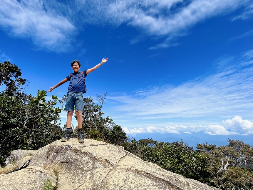
When this section began, we learnt the difficulty was due to rocks and we weren’t upset because we like climbing rocks, less boring than steps. They did make it slow going though and we once again needed frequent rest stops. We noted that the vegetation had thinned out and my mother spotted some silver ferns. For the 4km to 5km stretch we slowly but surely scrambled around the rocks but only I made the choice to get rid of my hiking stick and go in with both hands on the really steep parts. Just before the 5-kilometre shelter there was a beautifully slanted rock that flattened from where we got a show of some of the upper peaks of mount Kinabalu, we posed for some pictures and had a little break.
After doggedly making our way through the last kilometre of rocks we arrived at Laban Rata where we would be staying the night. We checked into a six-person dormitory room that luckily, we had all to ourselves. Then exhausted and hugry from the hours, kilometres and at an altitude of 3272.2m we devoured a tasty early dinner. At 5pm, we went to bed. While trying to doze off, we had a small problem as my throat was a bit scratchy, but it was solved with some warm tea from the cafeteria.
The next day we woke up dark and early at 2am and sleep-walked our way through the standard morning routine of brushing and changing. We had some breakfast with a lot of hot tea. Jerro came in and we were excited but there had been some rain overnight and everyone was waiting for rangers to come up with a decision on whether to allow the final trek to the summit. After some tense waiting, we were given the green light and we scurried about to grab our bags and hiking sticks, we were only carrying a little snack and water for this hike.
At about 02:45am we got started on the final section of the climb; we had to climb about 2.72km up to the mountain summit.
First there were some steps from the resort till a wooden platform decorated with flags. This section was relatively easy and we climbed up holding our sticks on one hand and the railing for support on the other.
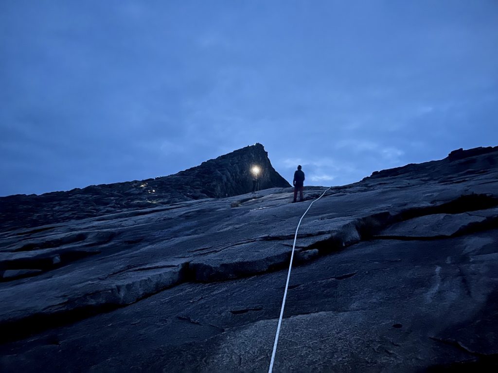
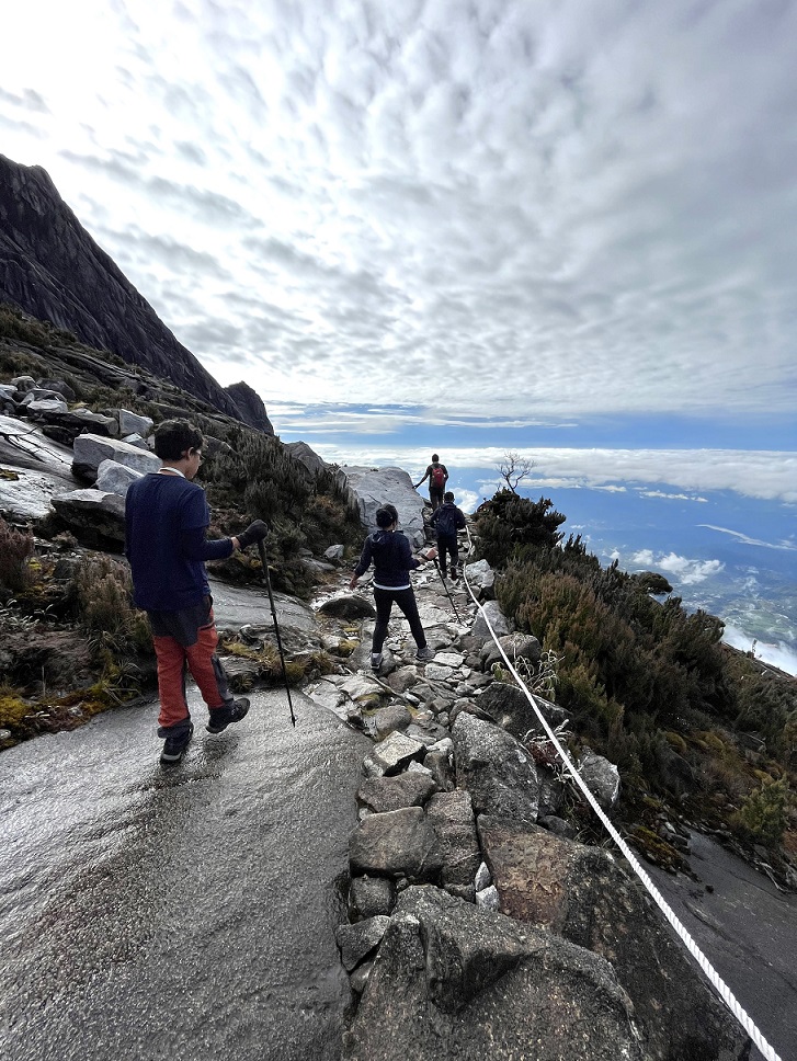
The next milestone was a check-point which we had to cross by 4am which we did comfortably in time so we realized we were making decent progress. You have to make it by 4 am otherwise there won’t be enough time for you to get back to the dormitory. After the checkpoint there was a steep slope with a rope down the middle that you had to grab to pull yourself up. There was meant to be about 300 metres of this in total. My mother struggled a bit in climbing this section but with a little help from Jerro she managed. My father and I held on tight and using our upper body strength pulled ourselves up.
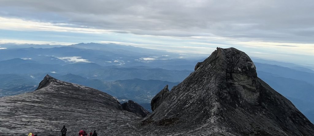
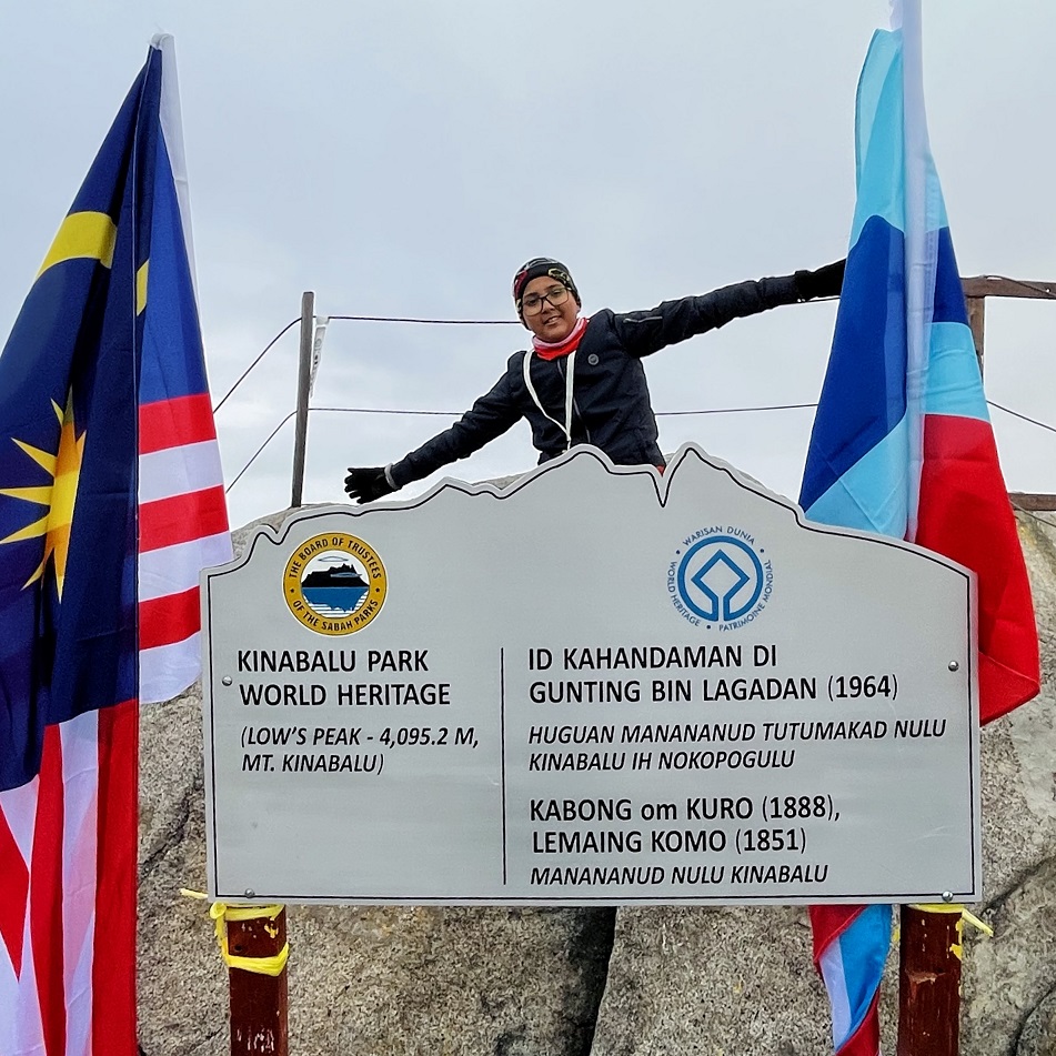
This led us onto the last part which was a steady upward climb. We had to struggle our way up a moderately steep incline and this was a true struggle for all of us because there was no flat section, it was a constant climb. The very last part involved climbing a rocky area with uneven landings. I was incredibly exhausted and was wondering if I had it in me to go all the way after all. Jerro pushed me to finish and I reached the top thoroughly exhausted but with a feeling of victory. We took a break to take in the view, clicked some pictures at the Summit point and then set off back down.
We first had to reach the night stay place at Laban Rata, check out of our room, and then complete the final descent. We moved fast, making good time clicking some pictures on the way down the rocks. The initial stretch down was a gentle downhill which was easy on the legs but then came the steep part when we reached the ropes that would lead us to the checkpoint. My father was very careful and went slowly holding onto the rope tightly. My mother and I had a blast, bum-baggoning (patent-pending) our way down holding the rope with our right hands while sliding down on our backsides. It was fun and simple and we were able to take the weight off our feet. On the steepest part of the trek, we carefully went down, still bum-baggoning but more slowly. After that we stood up dusted ourselves off and continued. This led to the part filled with stairs which my father shot down at top speed but my mother and I struggled a lot more. After making it back to the resort at 10am we had a quick breakfast, checked out, changed and began the trek back to the base. It was going to a really long day!
The first 2 kms down we had to tackle the rocky parts and this caused all of us a lot of strife. In the end we spent nearly two hours on this section. After a nice long break, we put on our ponchos as there was light rain and headed down towards the stairs. it was very difficult to handle the constant stairs and my mother had some pain in her left knee so for the rest of the trip she was limping along. I was also bothered by my ankle but I was still able to go down quickly over the stairs by ignoring the pain with all my might.
After about 1.5 km downwards and 2.5 km left, my father and I decided to go faster to see if we could reach before sunset and in a stunning show of speed shot down 1 km in a mere half hour. Sadly, in this attempt we ran out of water and had to wait for my mother and Jerro to catch up. We waited at the 1-kilometre shelter and were surprised to only have a short wait of around 5 minutes before my mother and Jerro appeared in our sights. With Jerro’s help, my mother had made good time as well. We fuelled up and filled up a bottle with water for our supply (Jerro was carrying our extra supplies as our guide-cum-porter), and then with my father in the lead me in the middle and my mother and Jerro bringing up the rear we forged ahead. My father and I completely missed the 0.5- kilometre sign and were looking for it as hard as we could. My mother told us that there were only 400 metres to go, and we were very pleasantly surprised. After walking across a bridge with confidence and following a path as well as ambling down some stairs we reached our final challenge.
The last 250 metres which on the way to the top of the mountain was a welcome downhill, now became a painful uphill that took all our determination to scale. My father and I were still hurrying out of pure wish to get out of the park and charged up the steps scaling them in a stunning 5 minutes. We checked out of the trail and waited for my mother to catch up. My father and I plopped down on some steps and waited for my mother and Jerro to catch up, flush with joy from our success of finishing the trek. Jerro clicked us a picture at the end point and later when we saw the picture, we realized how exhausted we looked.
We got into a van and drove to the park gate where we had met Jerro all that time ago. At the park gate, we met Olivia who had organized this trek. She was waiting for us with food and our colourful certificates of summit completion, thankfully they had spelled all our names correctly. We then piled into a van with the same driver who had brought us here and Olivia, this van drove us to our Mercure hotel in Kinabalu town. We ambled to the room, took warm showers, had a meal of chicken fried rice and chips, and went to sleep happy with our success.
After the trek we flew the next day to the Malaysian capital Kuala Lumpur where we spent a couple of days relaxing, sightseeing, shopping, and eating before heading back to our home in Mumbai via Singapore.
Sorry that the blog was so long but there was a lot to relate to you guys about the hike, below are a few important tips about climbing Mount Kinabalu.
- Make sure to have prepared well both climbing up stairs and climbing down stairs as we had practiced climbing up a lot but climbing down was a huge problem for us.
- Don’t try to show off and not use the shelters, you can skip one or two but skipping them all especially while going up is a bad idea. You should use everything that is given to help you climb.
- While training don’t forget to train your upper body so that you can pull yourself up the rope.
- Make sure to reach the checkpoint at 4 am as if you are late, you could be late to return to dormitory which closes at 10 am.
- Sabah Parks authority has a ton of tip, trick sand rules that can help you prepare for the climb. Check them out at https://www.mountkinabalu.com/tips/important-tips.
- Also invest in proper hiking equipment and a headlamp especially for the second day as you need the superior grip of hiking shoes and the light of a headlamp at 3 o’clock in the morning.